The following is the very rough itinerary, as far as I have it. I am using Back Roads in Indiana, by Charlie Myer for our routing. You can get this book through Hodson's Bay Co. here in my town, by the way!
Charlie has a significant amount of time and data collecting in the book and it sure looks to be useful! He has points of interest, camping. Well, without further ado, here we go, a rough outline of our tour! If you live in any of these Counties, feel free to comment in with any suggestions for your area!
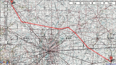
Above is a somewhat blurry topo map of the first four days
County List
Route notes, 30 counties, 660 miles!
1) Tippecanoe
2) Clinton
3) Boone
Camping: Old Mill Run
4) Hamilton
5) Madison
Camping: Pine Lake Camping and Fishing: (765)778-2697
6) Hancock
7) Henry
Campgrounds: Jellystone Park: 765-737-6585, GasAmerica Truckstop: 765-785-6820
Knightstown, Indiana
8) Rush
9) Fayette
10) Union
11) Franklin
12) Dearborn
13) Ohio County
14) Switzerland County
15) Jefferson County
16) Clark County
17) Floyd County
18) Harrison County
19) Crawford County
20) Perry County
21) Spencer County
Warrick County
23) Vandenburgh
24) Gibson
25) Knox
26) Sullivan
27) Vigo
28) Parke
29) Fountain
30) Warren
END: Tippecanoe


No comments:
Post a Comment